The Muse: August 2005From the PresidentCOME ONE, COME ALL,To our Annual Meeting on September 17. This is your Museum and we need your support. We will offer an interesting talk, good food and good conversation. We are entering our "slow down" time, getting our breath for a fall tour and Christmas. We will look forward to seeing you there! Details about these and other goings-on can be found in this newsletter. Be sure that you don’t miss them! Mary Frances Olinger, President If you haven’t voted for your favorite flowers in the voting booth at the Museum, be sure to do so soon! In September the election will be changed to favorite school subjects. Start thinking about yours--arithmetic, spelling, reading, art, science, recess, music, or write in your own! Annual MeetingThe Annual Membership Meeting will be on Saturday, September 17, 2005, at Mt. Olive Baptist Church, 160 West Court Street, Amherst, starting at 11:00 a.m. Marlene Fitzgerald will give an exciting presentation about America's 400th Anniversary to take place in 2007. Since Jamestown was the first permanent English settlement, Virginia will lead the way in celebrating. Come and hear how we can all be part of it! We will have a short history of Mt. Olive Church and a brief review of Museum accomplishments in the past year. Lunch will be served by the ladies of the church. We will have tomatoes stuffed with chicken salad plus all the "trimmings". Cost: $6.00. Please make reservations by September 9 at the Museum, 946-9068. Bring a prospective member. We depend on your support and participation! 
|
Advance Auto Parts Ambriar Pharmacy Amherst Dry Cleaner Amherst Pharmacy Bowen's Jewelry Burch and Ogden Central Virginia Printing Chi Chan's Chinese claudia's Florist Corner Nursery Depot Grille Designs by Robin Elkwood Salon Elston Inn Enchanted Antiques Essentials Exercise Estate Specialists Farm Basket |
Fun & Fitness Gregory Auto Hair Gallery Harris Tire High Peak Sportswear Hill Hardware Hill House His Place Restaurant Isabella's Restaurant John Simmons Gift Shop Kid Zany Children's Store La Pizzeria Le Bistro at Sweet Briar Loretta's Alteration Maxfields Meriwether's Restaurant Mill Ridge Gifts Montana Plains Bakery |
Moyanne Original Italian Pizza Pappy's Poplar Grove Golf Course Pyrocool Quizno Subs R. Coffee, Ltd. Rebec Vineyards Schewel's Silver Pig Silver Thistle Sweet Briar Bookshop The Patch Florist Tom Jones Pharmacy Travelers Restaurant Vintage on Main What a Blessing Winton Country Club |
What’s new in the library:
- Marriages and Deaths from Lynchburg, Virginia Newspapers, 1794-1836
- Campbell Chronicles and Family Sketches, by Ruth Hairston Early (2003 reprint)
- Proffit Family Genealogy (CD)
- The One Hundred Seventy Plus Year Old Mystery, by John Aubian Faulkner, 2002
- Some Descendants of Thomas Watts Jr., 1747 Virginia-1797 Georgia, & Hannah Rust Boggess, 1753 Virginia-1836 Alabama, by Fred A. Rutledge, Baltimore, MD, 1996
- Virginia Colonial Records, 1600s-1700s, Family Tree Maker, CD
- Virginia Will Records
- Index to Obituary Notices in the Religious Herald, 1828-1928, Works Project Administration
- American Militia in the Frontier Wars, 1790-1796, June Clarke Murtie
- Virginia Valley Records, John W. Wayland
Welcome to our new members!
- Amherst County Public Schools
- Library of Virginia
- Louis Basten, Lynchburg, VA
- Mr. & Mrs. George Dooley, Jr., Lynchburg, VA
- April Mullins, Amherst, VA
- Terry Parten, Frisco, TX
- Clint Proffit, Pedricktown, NJ
- Amanda Lee Smith, Marriottsville, MD
- Marilyn Veek, Frederick, MD
- Thomas D. Watts, Jackson, TN
Do you know someone who isn’t a member? The Museum values your membership and would like you to encourage your friends to join, too! Many of our members bring their visitors to see the Museum and family reunions are a wonderful opportunity to introduce your relatives to the resources that we now have in our growing research library. Make sure your friends and relatives don’t miss out on this opportunity to become a part of the Museum’s membership--truly one of the Museum’s most valuable assets!

Major Project
The re-pointing of the brick walls of the Museum has been a major undertaking. Randy Parr of Lynchburg Restoration, Inc. has been re-pointing the walls in two stages, as funds from grants have been realized. The first two walls were completed last year and he is currently working on the remaining walls. Lynchburg Restoration, Inc. is a corporate member of the Museum. The re-pointing has been a major project and, when completed, it will add to the overall appearance of the building. Thanks to the Greater Lynchburg Community Trust for their support in helping us to finish this project!
Van Tour
Plans are underway for another van tour on October 29. Mark your calendar now, and watch for further details in the next newsletter.
Exhibits Scheduled for Sorghum Festival
Look for the adjoining displays of the Amherst County Museum and Historical Society and the Jamestown 2007 Committee at this year’s Sorghum Festival in Clifford on Saturday, October first and Sunday, October second.
History buffs will be able to purchase books describing places, people, and events in Amherst County’s past. Bob Faught, author of Amherst Men in Gray, will be available to autograph his book about local residents who were soldiers during the Civil War.
Information about The Journey That Changed the World the voyage and settlement of the English colonists at Jamestown in 1607, will be available.
Your ideas to make the 400th anniversary celebration of the colony memorable in our area will be welcomed by the volunteers who have begun to coordinate local activities with those planned by agencies of the Commonwealth of Virginia.
New Exhibit in the Massie Gallery
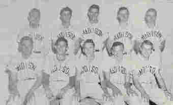
Above is shown the 1952 baseball team, Madison Heights High School. How many of these players do you recognize? Baseball has long been popular in Amherst and has produced some excellent ballplayers. In the 1970s the Amherst County High School garnered three state championships.
Below is shown another summer activity--riding is ever popular in Amherst County, too. Sweet Briar College’s equestrian program has long been a focal point for horse lovers of all ages.

Early Roads of Virginia and Amherst County, Part 1
from a lecture by Charles Hamble, delivered March 17, 2005
As one might imagine the first "roads" in Virginia were animal trails and Indian tracks. Animals often beat extensive paths leading to salt licks or mineral springs.
The American Indian laid out and marked a system of trails that connected far regions and various tribes. Some trails were for trading, some for war. In the Piedmont region there were two main trails: The Warrior Path in the valley and the Trading Path east of and paralleling the Blue Ridge.
Consequently, the first white explorers and long-hunters used these Indian trails as they moved out of the Tidewater and to the west. Later the white settlers also traveled on these trails and slowly improved and widened the tracks for horse back and wagon passage. Remember, the forests in Virginia in areas were so dense that one could travel only on foot.
The first written indication of a road in Virginia was "..... Rhode along the river bank"... in 1610. This phrase referred to the supply road from the ship dock to the fort at Jamestown. Later the "Greate Road" identified the main street in Jamestown extended to the Middle Plantation (later Williamsburg) on the mainland.
The development of roads in the Virginia Colony continued the basic English traditions as the earliest settlers were mostly Englishmen. In England, the matter of highways was based on English Common Law, and subsequently, the Road Law of 1555. The English Law placed the responsibility for construction and maintenance of roads upon the Parish--the smallest English Administrative unit. Moreover, the law required six days labor from each male parishioner (unpaid) to maintain the highways.
In 1632, the House of Burgesses enacted the first highway legislation in North America. The law required that the roads be laid out as required by the Governor, the Council and each parish. Also, each male was required to work on the roads in his parish or pay for a replacement. Obviously, this act of Burgesses was taken directly from the English Law. Surprisingly, this policy remained in effect for 250 years.
In succeeding years. the road laws were refined and became more specific. In 1657, the highway acts directed that all highways and bridges were to be surveyed yearly and maintained by the county courts; all county-to-county ways, ways to court houses and ways to churches were to be laid out and cleaned yearly as each county court thought fit.
Again in 1661 the law stressed the most convenient way to church, to court, county-to-county and to Jamestown. In 1705 legislation specifically directed the clearing and repairing of roads for the passage of carriages, of tobacco and of merchandise; the road was to be cleared from woods and bushes and roots removed and the road would be thirty feet wide; large bridges were to be erected by skilled labor and passages across dams were to be twelve feet wide; and county courts shall approve and govern river ferries. Of particular interest in this law was the directive to establish good roads from iron furnaces to a navigable creek or river.
In his "Notes on the State of Virginia" in 1785, Thomas Jefferson described the approach to handling road matters.
"The roads are under the government of county courts, subject to be controlled by the general court. They order new roads to be opened wherever they think necessary. The inhabitants of the county are by them laid off into precincts, to each of which they allot a convenient portion of the public roads to be kept in repair. Such bridges as may be built without the assistance of artificers (skilled workers or craftsmen), they are to build. If the stream be such as to require a bridge of regular workmanship, the county employs workmen to build it at the expense of the whole county. If it be too great for the county, the application is made to the General Assembly, who authorizes individuals to build it and to take a fixed toll from all passengers, or gives sanction to such other propositions as to them appear reasonable. Ferries are admitted only at such places as are particularly pointed out by law, and the rates of ferriage are fixed."
The following narrative describes the operation and governance of the highway system in a very basic manner as prescribed by law of the colony or state.
The justices of the county, meeting at public court in the county court house governed and managed the road system in the county. The proposal for a new road could be initiated by petition of a county citizen or by the observations of the gentlemen justices themselves. After discussion of the proposed road, the court made a decision concerning the new road. If a new road was to be opened, the court appointed a three man commission to view a convenient way from one point to another. VIEW means to lay out and mark the path, considering terrain, steep slopes, fords at streams and the least damage to private property.
At the next court the commission reported its findings and made a recommendation. At this time the court was open for comments from the public. If all went well, the court approved the way of the new road and appointed a road surveyor for the new segment. The road surveyor was actually the supervisor or overseer for that segment of the road. He was responsible for organizing and supervising the work gang who actually cleared and constructed the road. The surveyor was often the man who petitioned for the road and was the land owner along the path of the new road.
The surveyor's responsibilities did not end with the opening of the new road. He had to periodically survey or view the road for repairs or improvements and organize the work gang to do so. Usually, he was required to report to the court annually or upon any complaint.
The LABOUR GANG was also appointed by the court. The gang usually consisted of land owners serviced by or in the area of the road segment. The gang consisted of all TITHEABLES of the tasked landowners. A TITHEABLE was any male over sixteen years old, white or black, son, servant, or slave. Once a new road was opened, it had to be maintained and improved by the same named surveyor and labor gang. No one was paid for this work. It was hard labor for all - axe, pick, and shovel, grubbing hoe, horse and plow. Simple log and rock bridges had to be built across numerous small streams. Often the work was performed in the winter months in miserable weather - rain and cold. If one failed or refused to serve, the justices ordered the county Sheriff to investigate the circumstances of one's negligence of duty. The shirker could appeal to the court. If found negligent the court could levy a fine.
There were many early, notable roads in the Piedmont region. One of the first roads was the Mountain Road, better known as the Three Notch'D or Three Chopt road. Its path was from present day Richmond northeast through present day Charlottesville and over Woods Gap in the Blue Ridge into the Valley. Its name derived from axe marks on trees blazing the way. Originally it was a series of Indian and animal trails connected by settlers slowly improving the way as they moved west into the wilderness. Three Chopt road was not really planned - it just simply came about. Us Highway 250 closely follows the path of Three Chopt road.
Some of the first segments of Three Chopt appear in the Goochland County Court records of 1733 when the court ordered the improvement of part of the road "also known as the Mountain road." In 1734, the Goochland court appointed Peter Jefferson as "surveyor of road from mountains to Licking Hole Creek in the room of Henry Runnalls." Later, the name "Three Notch'D Road" appeared in the court records. Another important road was the SECRETARY'S ROAD named for John Carter, Secretary of the Colony (1690-1743). Carter patented 9350 acres just south of present day Charlottesville and established two quarters - Clearmont and Mill Quarter. The Mill Quarter was located at HWY 20 and Hardware River east of the Crossroads on US 29.
In 1740 Carter's employees began opening a road from the mill southwest and eventually to the Tye River and then on to Carter's 10,000 acre patent on the Piney River (just above Roses Mills). There was another of Carter's roads extending from the Fluvanna to his mill quarter. Finally there was the "Secretary's Ford" at the Rivana River (I-64 crossing) where later a bridge was built- and rebuilt after floods. John Carter never lived at his quarters in Albemarle or Amherst Counties.
The early court records of Goochland, Albemarle, and Amherst Counties are replete with road orders and other entries dealing with roads. What we take for granted (and pay with our taxes) today was very serious, important, and local to the citizens and their government in the early days of the colony. Following are examples extracted from the early court order books.
GOOCHLAND ORDER BOOK 1730-1731
Court- Tuesday 21 July 1730 Survey of the roads on a motion of Edward Scott - ordered that a road be cleared from the fork of the James River to the mouth of Rockland River. My Chamberlain, Coches and DIGGES titheables. John Phelps Surveyor.
ALBERMARLE Co ORDER BOOK - 1745
23 May 1745 O.S., p. 13 Road. On the motion of Robert Rose Clerk, leave is granted to him to clear a road from his plantations on Tye River to Leak's Plantation.
23 May 1745 O.S., p. 13 Road. On the motion of John Harvie leave is granted him to clear a road from the Mouth of Tye River to the Branches of Harris's Creek.
27 June 1745 O.S., P. 23 Road. William Cabell. Gent is appointed Surveyor of the High Way from the foard of Tye River to the Court House, the Male Tithables betwixt the said road and the river; and ??????
27 June 1745 O.S., P. 23 Diret. N & C. The Surveyors of several high ways within this county are ordered to setup posts with direction at the several forks of roads with in their respective districts; according to law, and that the said directions be set up at least ten feet from the ground.
25 July 1745 O.S., Horse P. 23 Scotts. ferry. On the motion of Daniel Scott leave is given to him to keep a ferry from the court house landing to the opposite side he giving cond. and security as the law requires.
26 Sept. 1745 O.S., P. 64 Road. Ordered that John Graves be overseer of the road from the mouth of the Tye River to the Branches of Harris's Creek and that all the Male Tithables between Buffaloe River and the Fluvanna (Charles Lavinder only excepted) do assist the said Graves in clearing the same.
26 Sept. 1745 O.S., P. 65 Road. Ordered that Moses Higginbottom be overseer of a road from the said Higginbottom's Mill a Cross Buffaloe to Mr. Harvey's Road and that the Male Tithables Between Buffaloe and the Secretarys Mountains do clear the same and that the said Gang do join Jon Graves's to the mouth of the Tye River.
16 Aug. 1746 O.S., p. 164 Road. Ordered the Road from Jones foard on Tye River be Continued to Swans Creek Mountain and from thence to the Mouth of Swans Creek and that the Secretarys Road be Continued from the Meadows to join John Harveys Road, and that the Widow Johnsons hands and the Inhabitanta of Buffaloe and Tye River be Aded to the hands formerly Appointed for Clearing the same, and that William Cabell Gent. be Overseer thereof,--